

Summary
Drylands now cover 40% of Earth’s land (excluding Antarctica), with an area larger than India turning arid over three decades, a UN study reveals.
This trend, driven by climate change and exacerbated by poor farming practices, poses significant risks to global food security and water resources, particularly in Africa and Asia.
By 2100, up to 60% of the global population may live in drylands.
Experts urge action, including cutting emissions, sustainable farming, and reforestation, warning of severe impacts on food security, poverty, and forced migration.
Let us not forget that this is primarily due to deforestation, whether directly (due to loss of tree cover for moisture retention) or indirectly (due to climate change).
Fun fact: Lake Baikal in Russia contains 20% of the world’s surface freshwater.
So Putin must be happy about this, unfortunately.
It’s really polluted though
Better polluted water than no water at all.
Wow. That would make it pretty similar to the great lakes.
And probably just as polluted. But like I told someone else, better polluted water than no water at all.
I mean we actually have a fair amount of regulation around it due to the Great Lakes Commission but its sorta diluted by it being a combination of states and provinces over two countries. I know indiana is alwaysa troublemaker with allowing bad things on michigan.
Indeed it is. I have the misfortune of living here (not close to the lake though) and reading the shit that goes on.
One of the biggest problems in the Great Lakes regions is there are dozens of major urban centers that not only draw their potable water from them, but also reintroduce their treated water back into the lakes … and water treatment as it exists now can’t remove the medication/drug/chemical cocktail.
So while the water is technically potable, in reality millions of people are drinking a mix of viagra, cocaine, fentanyl, diabetes meds, birth control, microplastics, and all the chemicals we flush down our toilets (ie: cleaning solutions).
Seems arbitrary to exclude Antarctica.
Replying to myself with some facts I had to look up.
Antarctica seems to have about 14.2M sq km of land, almost all of which is permanently covered with ice. The total land area on earth is about 148.9M sq km. That makes Antarctica 9.5% of the land mass. So 40% (a bit round) drylands excluding Antarctica would mean 36% drylands including Antarctica. I’m suspicious of the 40% number, but the Guardian thinks I’ve read too many articles with an ad blocker recently.
Finding how much land outside of Antarctica is covered with ice is harder. One thing that tips the balance to Antarctica is that there isn’t nearly as much land at the North Pole, although there is a lot of sea ice.
I found multiple estimates of Greenland ice area here. Seems like about 1.7M sq km may be a reasonable and recent estimate. That alone is 12% of the land mass of Antarctica. There are about 200,000 glaciers of various sizes elsewhere, but the largest seem to be under 10,000 sq km, so it’s a bit daunting to total them up. They’re also often measured by length rather than area, and in sub-polar regions they will change in size throughout the year. Ice caps on islands, meanwhile, may be larger than the land they sit on. So that’s going to make it hard to determine land covered by ice.
If I try to find out the total amount of land not permanently covered by ice, if there is any inaccuracy or inconsistency at all the subtraction of one large number from another could give a wildly incorrect result.
Those calculation difficulties may be reason enough to treat Antarctica as special because of convenience, as I mention elsewhere. Is that a valid reason to write 40% instead of 36%? Sure, for lay writing.
Antarctica doesn’t really count as land. Except the coast, the actual land is inaccessible, it’s all covered in ice.
For now, anyway. Its melting is accelerating.
Antarctica doesn’t really count as land.
You’re more correct than you know: even when it does all melt, what seems now to be a single continent is actually going to be more like a big archipelago:
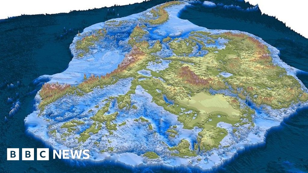
(Not sure if isostatic rebound will eventually bring it all above sea level or not.)
I mean, yes, there’s land there, but it’s less than people think.
